


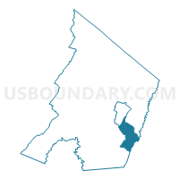
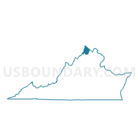
Shenandoah Voting District, Frederick County, Virginia
About
Outline

Summary
| Unique Area Identifier | 681720 |
| Name | Shenandoah Voting District |
| County | Frederick County |
| State | Virginia |
| Area (square miles) | 12.48 |
| Land Area (square miles) | 12.41 |
| Water Area (square miles) | 0.07 |
| % of Land Area | 99.44 |
| % of Water Area | 0.56 |
| Latitude of the Internal Point | 39.10778730 |
| Longtitude of the Internal Point | -78.14795170 |
Maps

Graphs
Select a template below for downloading or customizing gragh for Shenandoah Voting District, Frederick County, Virginia


Neighbors
Neighoring Voting District (by Name) Neighboring Voting District on the Map
- Canterburg Voting District, Frederick County, VA
- Carpers Valley Voting District, Frederick County, VA
- Frederick Douglass Voting District, Winchester city, VA
- Parkins Mill Voting District, Frederick County, VA
- Stephens City Voting District, Frederick County, VA
- War Memorial Voting District, Winchester city, VA
- White Post Voting District, Clarke County, VA
Top 10 Neighboring County Subdivision (by Population) Neighboring County Subdivision on the Map
- Winchester city, Winchester city, VA (26,203)
- Shawnee district, Frederick County, VA (14,987)
- Opequon district, Frederick County, VA (12,633)
- White Post district, Clarke County, VA (2,616)
Top 10 Neighboring Place (by Population) Neighboring Place on the Map
Top 10 Neighboring Unified School District (by Population) Neighboring Unified School District on the Map
- Frederick County Public Schools, VA (78,305)
- Winchester City Public Schools, VA (26,203)
- Clarke County Public Schools, VA (14,034)
Top 10 Neighboring State Legislative District Lower Chamber (by Population) Neighboring State Legislative District Lower Chamber on the Map
- State House District 33, VA (113,100)
- State House District 29, VA (88,049)
- State House District 18, VA (82,817)
Top 10 Neighboring State Legislative District Upper Chamber (by Population) Neighboring State Legislative District Upper Chamber on the Map
Top 10 Neighboring 111th Congressional District (by Population) Neighboring 111th Congressional District on the Map
Top 10 Neighboring Census Tract (by Population) Neighboring Census Tract on the Map
- Census Tract 510, Frederick County, VA (9,391)
- Census Tract 508.02, Frederick County, VA (7,274)
- Census Tract 508.03, Frederick County, VA (6,921)
- Census Tract 3.02, Winchester city, VA (5,327)
- Census Tract 3.01, Winchester city, VA (5,066)
- Census Tract 509, Frederick County, VA (4,357)
- Census Tract 508.01, Frederick County, VA (3,886)
- Census Tract 102, Clarke County, VA (3,055)
Top 10 Neighboring 5-Digit ZIP Code Tabulation Area (by Population) Neighboring 5-Digit ZIP Code Tabulation Area on the Map
- 22630, VA (30,292)
- 22602, VA (28,443)
- 22601, VA (27,813)
- 22655, VA (19,328)
- 22620, VA (2,348)
- 22663, VA (1,536)